


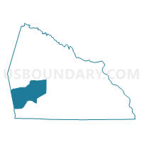
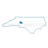
Voting District 04, Rowan County, North Carolina
About
Outline

Summary
| Unique Area Identifier | 641333 |
| Name | Voting District 04 |
| County | Rowan County |
| State | North Carolina |
| Area (square miles) | 40.86 |
| Land Area (square miles) | 40.78 |
| Water Area (square miles) | 0.09 |
| % of Land Area | 99.79 |
| % of Water Area | 0.21 |
| Latitude of the Internal Point | 35.59758980 |
| Longtitude of the Internal Point | -80.66410910 |
Maps

Graphs
Select a template below for downloading or customizing gragh for Voting District 04, Rowan County, North Carolina


Neighbors
Neighoring Voting District (by Name) Neighboring Voting District on the Map
- Voting District 05, Rowan County, NC
- Voting District 08, Rowan County, NC
- Voting District 09, Rowan County, NC
- Voting District 19, Rowan County, NC
- Voting District 21, Rowan County, NC
- Voting District 24, Rowan County, NC
- Voting District 29, Rowan County, NC
- Voting District 44, Rowan County, NC
- Voting District CC3, Iredell County, NC
Top 10 Neighboring County Subdivision (by Population) Neighboring County Subdivision on the Map
- Coddle Creek township, Iredell County, NC (32,599)
- China Grove township, Rowan County, NC (24,501)
- Locke township, Rowan County, NC (14,149)
- Atwell township, Rowan County, NC (12,428)
- Steele township, Rowan County, NC (1,725)
- Mount Ulla township, Rowan County, NC (1,692)
Top 10 Neighboring Place (by Population) Neighboring Place on the Map
Top 10 Neighboring Unified School District (by Population) Neighboring Unified School District on the Map
Top 10 Neighboring State Legislative District Lower Chamber (by Population) Neighboring State Legislative District Lower Chamber on the Map
- State House District 95, NC (94,835)
- State House District 76, NC (71,116)
- State House District 77, NC (67,312)
Top 10 Neighboring State Legislative District Upper Chamber (by Population) Neighboring State Legislative District Upper Chamber on the Map
Top 10 Neighboring 111th Congressional District (by Population) Neighboring 111th Congressional District on the Map
- Congressional District 12, NC (736,346)
- Congressional District 6, NC (714,412)
- Congressional District 10, NC (689,468)
Top 10 Neighboring Census Tract (by Population) Neighboring Census Tract on the Map
- Census Tract 517, Rowan County, NC (7,818)
- Census Tract 516, Rowan County, NC (6,499)
- Census Tract 519.01, Rowan County, NC (4,637)
- Census Tract 518.02, Rowan County, NC (4,574)
- Census Tract 518.01, Rowan County, NC (4,148)
- Census Tract 613.03, Iredell County, NC (4,115)
- Census Tract 614.08, Iredell County, NC (3,541)